Cycle touring the North Cape - Tarifa Route
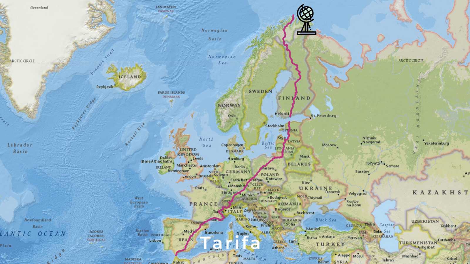
Another ultracycle race route across Europe, which we check for its suitability for cycle touring: With 7400km the North Cape - Tarifa Race is said to be the longest bike race in the world and to have one of the safest routes! In 2022 it took place for the third time. In this post you will find everything about the NCTA route from north to south across Europe, the interactive map with similar routes, and the GPX file to download.
North Cape - Tarifa 7400 km every 2 years since 2018
Every 2 years on midsummer night, on June 20th, starts the bike race from the northernmost to the southernmost point of Europe. When registering, participants can indicate how far they would like to ride. There are 4 options to choose from: to Helsinki (1753 km, 15000 vertical meters), to Bregenz (4070 km, 28000 vertical meters), to Nice (5370 km, 48100 vertical meters) or Tarifa (7370 km, 80000 vertical meters). As you can see, the Alps and Spain are responsible for the lion's share of the vertical meters.
Altogether the route crosses 15 countries. There is no time limit, and the winner gets all kudos. Here you'll find the North Cape - Tarifa website. The ultracycle race usually abbreviates to NCTA.
Who made the North Cape - Tarifa Cycle Route?
Transbike Adventures is the organization that organizes the North Cape - Tarifa race and a number of other international ultracycle races. For example, the Iberica Traversa in 2 variants, one over gravel and one on the road, the Morocco Bike Adventure or the Alaska Divide. Pretty adventurous.
You can find the team on the Transbike Adventures website. Andy Buchs is responsible for the North Cape Tarifa race and created the route. Here you can find who was involved in planning the route.
The safest bike race route across Europe
“The race organizer Andi Buchs had set out not only to make a challenging race, but above all one which was VERY safe. I can count on one hand the number of times I felt I was on a dangerous road over the entire 7,390 km. And that is with fingers to spare.
This really set the race apart from others where the organizers either are not overly concerned about the traffic situations, or allow riders to select their own routes. It is simply impossible to know how safe a road is without being there on your bike, and Andi rode the entire route when planning the race.”
– Christopher Ross Bennett
Source: Christopher's blog article on his North Cape - Tarifa experience
So let's take a closer look at this promising route. Closer means that we have traced the route down to village level. You'll get the guaranteed accurate route if you register for the race. The organizers put a lot of effort into updating the route each year and you can even find a change log of the route.
Course of the route compared to other routes through Europe
Norway
The race starts at midnight. This is practical, because the short stretch from the North Cape to Alta takes you through 7 tunnels. The tunnel from the North Cape to the mainland is the longest and deepest. You need additional light. You want to use the quietness of the night to cross the tunnels. When there is traffic, tunnels are noisy and uncomfortable. Here you will find detailed information about each tunnel.
Finland
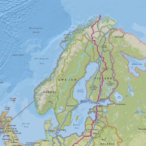
The route leads all the way through Finland. There isn't that much choice of roads here. But as we pointed out in our article about cycling routes in Finland, you could traverse Finland entirely on forest trails. Well, Andi Buchs doesn't send the participants of the North Cape - Tarifa race onto forest roads, but on small roads.
The route differs from other major routes running through Finland, such as the EuroVelo 11 or NorthCape4000 routes. First, the route runs from the North Cape to the mainland on the same road as EuroVelo 1. But at the first change of direction to the south you are already cycling on new paths. A small part of the route runs on EuroVelo 7 and another section on EuroVelo 11. However, large parts of the Finnish section of the route do not coincide with any other international route and still run on roads and national cycle routes.
Poland, Czech Republic, Germany and Alps
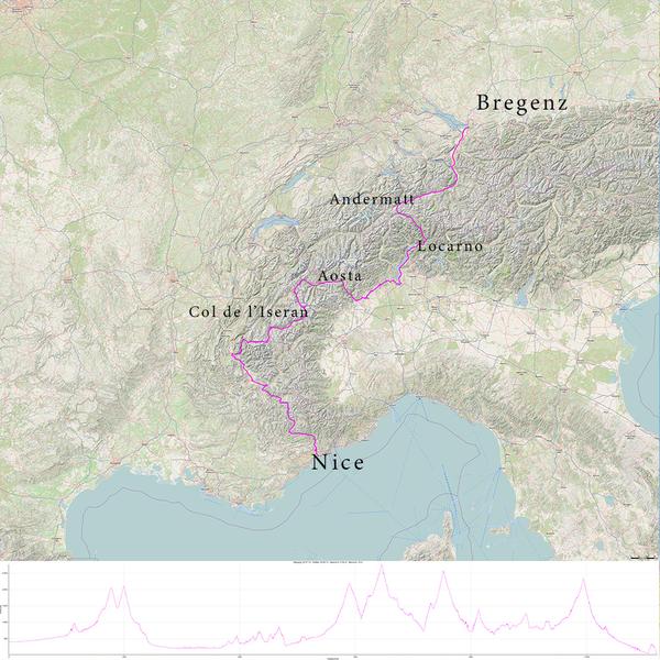
Also in Poland and Germany, the route uses national and regional bicycle routes and none of the well-known international routes. At Lake Constance it starts to follow the Rhine Cycle Route and crosses the Alps in Andermatt (Oberalp Pass 2046 m). Then the route turns south to Locarno and west to Aoste. South of Aoste you can look forward to the highest alpine pass, the Col d'Iseran at 2764 m. From Seez to Mizoën, the route follows the Route des grandes alpes.
The route meanders thoughtfully through the Alps and only joins the EuroVelo 8 again in Nice. It doesn't shy away from height meters. Along the 1120 km from Bregenz on Lake Constance to Nice on the Mediterranean Sea you climb 20000 m.
Spain
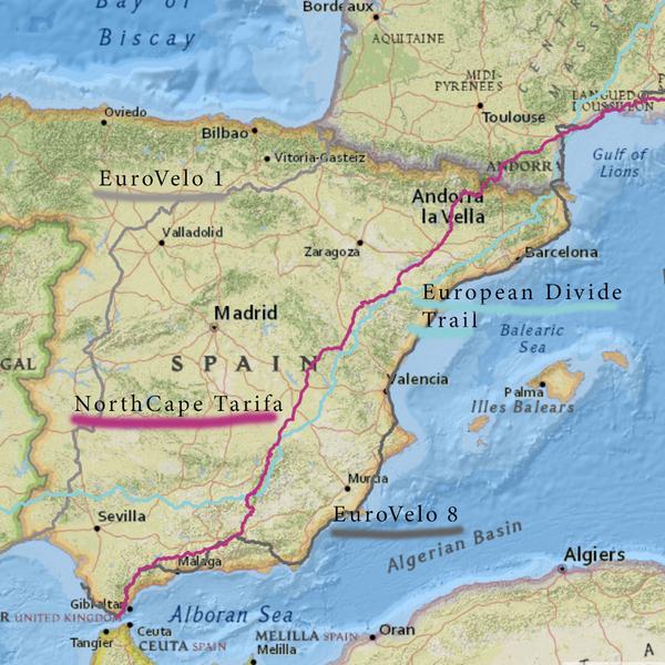
The NCTA route brings you via Andorra to the Iberian Peninsula. From Ax-les-Thermes you climb the Pyrenees via the mountain pass Port d'Envalira (2407 m), a moderate pass with an average gradient of 4.8%. The route occasionally meets the Europe Divide Trail in Spain and one time the EuroVelo 8 in Granada. Both routes also run north-south through eastern Spain.
The Sierra Nevada west of Granada is responsible for quite some elevation change of the route. Participants have to cycle a sporty detour to the Pico del Veleta (3398 m), the highest point of the whole route, which is also a checkpoint in the race. Then the route continues through a very hilly landscape until the finish in Tarifa.
Bike touring the North Cape - Tarifa Route?
Yes, for the route from the North Cape to Bregenz. The route is not too demanding, interesting, varied, and complements existing international routes; and it runs on asphalt wherever possible. In addition, it is said to be safer than other ultracycle race routes.
Challenging
From Bregenz, if you want to go further south, you will have to cross the Alps. The North Cape - Tarifa route takes you on smaller roads and at the same time makes for a worthwhile scenery. Of course, some of the passes have quite some traffic. Whether you want to cover that many vertical meters on your touring bike with luggage on your cycling vacation depends on how trained you are and how fast you want to travel. What does bicycle travel mean to you?
From Bregenz, if you want to go to Spain, the only flat alternative is to go via western France. If that is not an option for you, then the North Cape - Tarifa route via Andorra through the Pyrenees is an interesting choice. There is hardly an easy route through Spain: Heat, wind and steep climbs require significant effort to enjoy the country's special scenery. Spring is ideal for cycling in Spain. But if you come from the North Cape you will reach Spain in September.
Race routes can be varied, creative and now and then too demanding for bike travelling with luggage through Europe. It's a good idea to bring plenty of time to try it out and have a plan B ready. So...
Get on your bike, share the most beautiful, the safest, the shortest, the longest or the most practical bike routes with others. Talk about cycle touring. Give away a bike or a bike day! Just don't give up until everyone's riding bikes. Because cycling makes you happy.
The maps in this article were created with MapHub using the National Geographic, Esri, DeLorme, HERE, UNEP-WCMC, USGS, NASA, ESA, METI, NRCAN, GEBCO, NOAA, iPC map. Some maps in this article were created with GPXSee using the 4U map, data CC BY-SA by OpenStreetMap.


